Lismore Fort


Lismore Comprehensive School lies in the townland of Drumgask, Craigavon, which is about 2 miles from Lurgan centre.
The school got the name "Lismore" from the Irish gaelic name "Lios Mor", which means "big fort".
The fort in question lies to the south side of the school and was an early christian settlement. It dates between 900A.D. and 1200A.D. as does Lisnamintry which is another early settlement and is approx. 2 miles away from Lismore.
All original traces of the buildings and fencing have long since gone, but most of the defensive ditch that surrounded the settlement is still visible. There are still large boulders on the site that mark the entrance to the settlement.
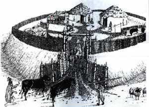 The "Lios" was commonly a circular fort, built on a hilltop. The size of these forts ranged from 20 to 50 meters. Usually it consisted of large mud walls and an outer ditch that enclosed a level area containing wooden hauts with thatched roofs. The bank and ditch provided good protection from wild animals and adversaries for the farming families and their livestock that lived within the settlement. The "Lios" was commonly a circular fort, built on a hilltop. The size of these forts ranged from 20 to 50 meters. Usually it consisted of large mud walls and an outer ditch that enclosed a level area containing wooden hauts with thatched roofs. The bank and ditch provided good protection from wild animals and adversaries for the farming families and their livestock that lived within the settlement.
In Irish language sources they are known by a number of names: ráth (anglicised rath, also Welsh rath), lios (anglicised lis; cognate with Cornish lis), caiseal (anglicised cashel), cathair (anglicised caher or cahir; cognate with Welsh caer, Cornish and Breton ker) and dún (anglicised dun or doon; cognate with Welsh and Cornish din). The ráth and lios was an earthen ringfort; the ráth being the enclosing bank and the lios being the open space within. The caiseal and cathair was a stone ringfort. The term dún was usually used for any stronghold of importance, which may or may not be ring-shaped.
In Ireland, over 40,000 sites have been identified as ringforts and it is thought that at least 50,000 ringforts existed on the island. They are common throughout the country, with a mean density of just over one ringfort within any area of 2 km2 (0.8 sq mi). It is likely that many have been destroyed by farming and urbanisation. However, many hitherto unknown ringforts have been found thanks to early Ordnance Survey maps, aerial photography, and the archaeological work that has accompanied road-building.
This particular fort has not been excavated. Though, if it was shards of bone and pottery would be discovered.
The fort at Lismore School was included in a map dated 1834 for the area. It was also included in a map dating from 1964.
The information on this website is free and will always be so. However, there are many documents and records that we would like to show here that are only available for sale. If you would like to make a donation to the Lurgan Ancestry project, however small (or large!), to enable us to acquire these records, it would be very much appreciated. We could cover our pages in Goggle Ads to raise money, but feel that this would detract from the information we are trying to provide.
You can also help us to raise money by purchasing some of our ebooks on our sister website: www.genealogyebooks.com
The Lurgan Ancestry Project is a not for profit website, all monies raised from the site go back into it. Genealogy Ebooks is our sister website and takes payments on our behalf.


| 